Yavapai County Interactive Map
Help | FAQ’s | Contact Us
Hold down Shift key to select multiple parcels.
Please choose Coordinate System to label.
Map Scale:

Not all basemaps are visible at 1:500 scale.
Disclaimer: Map and parcel information is believed to be accurate but accuracy is not guaranteed. No portion of the information should be considered to be, or used as, a legal document. Users should independently research, investigate and verify all information.
By using this website, the user knowingly assumes all risk of inaccuracy and waives any and all claims for damages against Yavapai County and its officers and employees that may arise from the use of this data and agrees to indemnify and hold harmless Yavapai County and its officers and employees to the fullest extent permitted by law. By using this website, the user also agrees that data and use of this website may not be used for commercial purposes.
By using this website, the user knowingly assumes all risk of inaccuracy and waives any and all claims for damages against Yavapai County and its officers and employees that may arise from the use of this data and agrees to indemnify and hold harmless Yavapai County and its officers and employees to the fullest extent permitted by law. By using this website, the user also agrees that data and use of this website may not be used for commercial purposes.
Tools:
Save the map extent for future reference:
Note: These bookmarks last for 45 days
Used to save the layers and extent of the map to open in another web browser.
Note: These bookmarks last for 45 days
Bookmark URL
Used to save the layers and extent of the map to open in another web browser.
Select Shape Options:
Color:
Point Shape:
Line Options:
Polygon Options:
Buffer Options:
feet
Select a shape to draw on map.
Right-click a Graphic to access menu options.
Text Options:
Color:
Please enter text below.
Right-click a Graphic to access menu options.
Color:
Please enter text below.
Right-click a Graphic to access menu options.
Add a zipped shapefile to the map.
Visit the Shapefiles help topic for information and limitations.
Files Loaded:


No results to display.
Ownership Information 
|
| , |
| Recorded Documents & Sales ()
|
|
|
| Physical Address
|
| Check Digit
|
|
Assessor Acres
|
|
Subdivision
|
|
Map Type
|
| Local Zoning
Yavapai County Zoning Setback Table 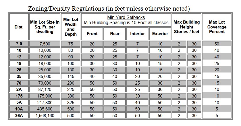
|
| Section Township Range
|
| Homestead
|
| Incorporated Area
|
| Tracts
|
| USGS Quad
|
| Mining Claim
|
| Improvements ()
|
|
|
|
Improvements are for Assessment purposes only and does not imply that building permits have been obtained. |
| Building Sketches ()
|
|
|
Starting with the 2015 tax year, the Limited Property Value is the only value considered
for taxation purposes, the Full Cash Value is no longer used for taxation.
| Tax Year | 2026 | 2025 |
| Assessed Value(ALV)
|
||
| Limited Value(LPV)
|
||
| Full Cash(FCV)
|
||
| Legal Class
| ||
| Assessment Ratio
|
% | % |
| Usage Code
|
| Tax Area Code 2025 Taxes Billed | |


|
|
| Fire District
|
| School District
|
| Water District
|
| Street Improvement District
|
| Street Light District
|
| Facility District
|
| Hospital District
|
| Sanitary District
|
| Irrigation District
|
| Election Precinct
|
| Congressional District
|
| Legislative District
|
| Supervisor District
|
| College District
|
Enter a title for your map (optional):
Select:(choose landscape if you want a legend)
Portrait Landscape
Include Scalebar and North Arrow
Select:(choose landscape if you want a legend)
Portrait Landscape
Include Scalebar and North Arrow
Enter a title for your map (optional):
Select: (choose landscape if you want a legend)
Portrait Landscape
Include Scalebar and North Arrow
Select: (choose landscape if you want a legend)
Portrait Landscape
Include Scalebar and North Arrow
Export Map:
Select Layout Template:
Select Size:
Select Orientation:
Add Legend:
Enter a title for your map (optional)
Select Format:
Include Georef info?